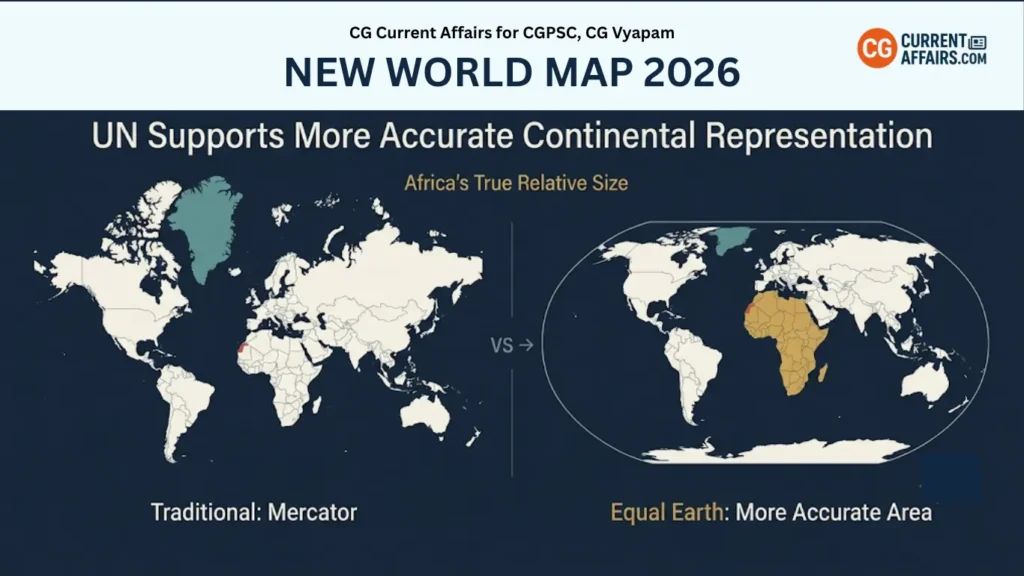
The New world map 2026 has become an important development in geography and cartography after the United Nations backed an initiative for a more accurate representation of the size of continents, particularly Africa.
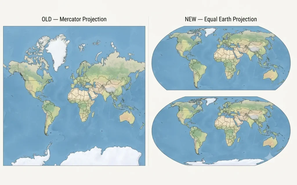
The move highlights the limitations of the traditional Mercator projection, which makes areas near the poles appear much larger than their actual size.
The UN-supported approach encourages the use of equal-area projections, especially the Equal Earth projection, to provide a more balanced representation of global land areas.
Why in news?
The United Nations General Assembly supported the “Correct the Map” initiative, which seeks to promote more accurate geographical representations.
Key facts:
- Resolution sponsor: Togo
- Support: African Union members
- Votes in favour: 164
- Against: United States
- Abstentions: 6
- Nature of resolution: Non-binding
The decision does not legally require countries to replace the Mercator map. Instead, it encourages governments, schools and institutions to consider more appropriate projections.
Why Is the New World Map 2026 in the News?
The debate is mainly connected with the area distortion caused by the Mercator projection.
The Mercator projection was developed by Gerardus Mercator in 1569 and was primarily designed for maritime navigation.
Major problem with Mercator
As distance from the Equator increases, land areas appear increasingly enlarged.
This creates a major difference between the visual size and actual size of continents and countries.
Example:
- Greenland appears extremely large on a Mercator map.
- Africa appears comparatively smaller.
- In reality, Africa is around 14 times larger than Greenland.
Therefore, the current debate focuses on using different projections when the purpose is to compare the actual area of continents.
New UN World Map: What Is Being Proposed?
The New UN map does not mean that the United Nations has created one compulsory replacement map for the entire world.
Instead, the initiative promotes the use of appropriate map projections for different purposes.
The Equal Earth projection is one of the major projections associated with this initiative.
Important Point
There is no single perfect world map projection.
The Earth is three-dimensional and approximately spherical, while a conventional map is two-dimensional.
Therefore, every projection involves some form of distortion in:
- Area
- Shape
- Distance
- Direction
The objective is to select the projection that best suits the purpose of the map.
New World Map Projection: Equal Earth
The New world map projection approach gives greater importance to accurate representation of land areas.
The Equal Earth projection is an equal-area, pseudocylindrical projection developed in 2018.
Developed by
- Bojan Šavrič
- Tom Patterson
- Bernhard Jenny
Main objective
The projection was designed to show the relative size of continents more accurately while maintaining visually balanced continental shapes.
Key Features of Equal Earth Projection
The Equal Earth projection has several important characteristics:
- Equal-area: Relative land areas are represented accurately.
- Balanced shapes: Continents retain familiar and visually pleasing outlines.
- Reduced polar exaggeration: High-latitude regions are not enlarged as dramatically as in Mercator.
- Straight parallels: Lines of latitude remain straight and horizontal.
- Flexible centering: The map can use different central meridians.
Why is Equal Earth Projection important?
The projection makes it easier for students and the general public to understand the actual relative size of continents.
This is particularly relevant to the representation of Africa, whose size is significantly underestimated visually on Mercator maps.
Mercator Projection vs Equal Earth
Understanding the difference between these two projections is important for geography examinations.
| Feature | Mercator | Equal Earth |
|---|
| Developed | 1569 | 2018 |
| Creator(s) | Gerardus Mercator | Šavrič, Patterson & Jenny |
| Type | Conformal | Equal-area |
| Main purpose | Navigation | Area comparison/general representation |
| Area accuracy | Distorted | More accurate |
| Polar regions | Greatly enlarged | Less exaggerated |
| Africa | Appears relatively smaller | More accurately represented |
Exam Point
Mercator is useful for navigation, while Equal Earth is better suited to comparing the actual surface areas of continents.
Why Is Africa Central to the Map Debate?
Africa is at the centre of the discussion because the continent is located largely around the Equatorial region, while the Mercator projection significantly enlarges areas towards the poles.
As a result, Africa can appear much smaller compared with northern regions than its actual area would suggest.
Supporters of the campaign argue that:
- Maps influence geographical understanding.
- Distorted visual representation can affect perceptions of Africa.
- Africa’s geographical and economic importance should be represented more accurately.
- Educational maps should provide a clearer understanding of continental size.
African countries have also connected the issue with the historical legacy of colonialism and the way geographical information has traditionally been presented.
New World Map 2026 and the African Union
The African Union (AU) has been an important supporter of the move towards the Equal Earth projection.
According to the provided information, the 54 AU member states adopted the Equal Earth projection in February.
The objective was to promote a representation that better reflects the actual relative size of continents, particularly Africa.
Key Fact
African Union: 54 member states
The development has strengthened the campaign for wider use of equal-area maps in education and public communication.
Significance of the New World Map 2026
The issue is significant because maps are not merely geographical tools. They can influence how people understand the size, importance and position of different regions.
The initiative could encourage changes in:
- School textbooks
- Educational materials
- Government documents
- Media graphics
- Digital mapping platforms
- Public information resources
However, adoption is expected to depend on the purpose of the map and the decisions of individual institutions and countries.
Is the New UN Map Replacing Mercator?
No.
This is one of the most important points to remember.
The UN resolution is non-binding, so it does not force countries to stop using Mercator.
Mercator can still be useful for:
- Maritime navigation
- Direction and bearing calculations
- Certain aviation and navigation applications
Equal-area projections are more suitable for:
- Comparing continental sizes
- Geography education
- Thematic maps
- Public information
- Showing relative land areas
Therefore, the New UN map approach is better understood as an effort to encourage purpose-specific map projections, rather than an immediate replacement of Mercator.
France and the Map Projection Debate
France supported the resolution and indicated that it would move away from relying on Mercator for purposes where other projections are more suitable.
France plans to use the Eckert IV projection, which also focuses on more accurate representation of surface areas.
Important Point
The use of different projections demonstrates that one map cannot perform every geographical function equally well.
Why Did the United States Oppose the Resolution?
The United States voted against the resolution.
According to the provided information, the US argued that the UN General Assembly should focus on major international issues rather than what it viewed as a map-related initiative.
The resolution nevertheless received overwhelming support from the General Assembly.
New World Map 2026 PDF: What Should Students Study?
Students searching for a New world map 2026 pdf should focus on the concept of map projections, rather than looking for a single compulsory replacement map.
For examinations, remember:
Mercator Projection
- Developed in 1569
- Created by Gerardus Mercator
- Primarily designed for navigation
- Preserves angles and directions
- Causes significant area distortion
- Enlarges regions near the poles
Equal Earth Projection
- Developed in 2018
- Created by Bojan Šavrič, Tom Patterson and Bernhard Jenny
- Equal-area projection
- Represents continental areas more accurately
- Reduces extreme polar exaggeration
- Useful for general geographical representation
Importance for Geography and Competitive Exams
The debate surrounding the New world map 2026 provides an important example of how cartographic projections influence geographical understanding.
For competitive examinations, students should understand:
- Why the spherical Earth cannot be perfectly represented on a flat map.
- What the Mercator projection is.
- Why Mercator creates area distortion.
- Why Greenland appears disproportionately large.
- What an equal-area projection means.
- What the Equal Earth projection is.
- Why Africa is central to the current debate.
- Why the UN resolution is non-binding.
Key Takeaways
The New world map 2026 debate is fundamentally about accurate geographical representation rather than simply replacing one map with another.
The Mercator projection remains valuable for navigation because it preserves angles and directions. However, it is not suitable for accurately comparing the surface areas of continents.
The Equal Earth projection provides an alternative by maintaining relative land areas and reducing the visual exaggeration of high-latitude regions.
One-Line Revision
Mercator → Navigation → Conformal → Area distortion
Equal Earth → Area comparison → Equal-area → More accurate continental size
CGPSC Prelims Quick Revision
| Topic | Fact |
|---|
| Current issue | New world map 2026 |
| Campaign | “Correct the Map” |
| Sponsor | Togo |
| Votes in favour | 164 |
| Votes against | United States |
| Abstentions | 6 |
| Resolution | Non-binding |
| Mercator | Developed in 1569 |
| Mercator’s creator | Gerardus Mercator |
| Equal Earth | Developed in 2018 |
| Equal Earth creators | Šavrič, Patterson & Jenny |
| Equal Earth type | Equal-area, pseudocylindrical |
| Major issue | Area distortion |
| Major focus | Accurate representation of Africa |
CGPSC Prelims Practice Questions
Q1. Consider the following statements regarding the Mercator Projection:
- It was developed by Gerardus Mercator in 1569.
- It is a conformal projection that preserves angles and directions.
- It accurately represents the relative area of continents.
- Areas near the poles appear disproportionately larger.
Which of the statements given above are correct?
A. 1 and 2 only
B. 1, 2 and 4 only
C. 2, 3 and 4 only
D. 1, 2, 3 and 4
Correct Answer: B. 1, 2 and 4 only
Q2. Consider the following statements about the Equal Earth Projection:
- It is an equal-area projection.
- It was developed in 2018.
- It was developed by Bojan Šavrič, Tom Patterson and Bernhard Jenny.
- It completely eliminates all forms of distortion from a world map.
Which of the statements given above are correct?
A. 1 and 2 only
B. 1, 2 and 3 only
C. 2, 3 and 4 only
D. 1, 2, 3 and 4
Correct Answer: B. 1, 2 and 3 only
Q3. With reference to the debate over the New World Map 2026, consider the following statements:
- The Mercator projection tends to make Greenland appear much larger relative to its actual area.
- Africa’s actual area is substantially larger than its visual representation on a Mercator map suggests.
- Equal-area projections are useful for comparing the relative surface areas of continents.
- The UN-backed resolution legally requires all countries to stop using the Mercator projection.
Which of the statements given above are correct?
A. 1, 2 and 3 only
B. 1 and 3 only
C. 2 and 4 only
D. 1, 2, 3 and 4
Correct Answer: A. 1, 2 and 3 only
CGPSC Mains Practice Question
Q. Explain the limitations of the Mercator projection. How does the Equal Earth projection provide a more accurate representation of continental areas?